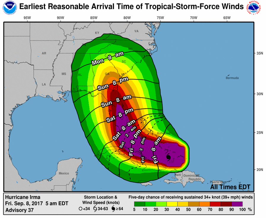
Tropical storm force winds, an offshoot of Hurricane Irma, are expected to move into north Georgia, including the Gainesville area, by Monday night and continue into Tuesday,
The winds will be accompanied by heavy rains, 2-5 inches in places. Rainfall amounts will be limited because of the forward speed of the system, according to the National Weather Service in Peachtree City.
"Sunday will be the last relatively quiet day as the surface high pressure centered over the Great Lakes region continues to supply mostly dry conditions for the northern half of the area," according Friday morning's 11:00 NWS update on the storm. "However, as the outer fringes of Irma begin to work their way into the area from the south, rain chances will steadily increase across central Georgia through the day Sunday. Breezy conditions will also be on the increase on Sunday..."
The National Hurricane Centerl forecast track centers squarely on north Georgia by late Monday into early Tuesday.
"This track trend continues to imply more widespread impacts from a then-weakening Tropical Storm Irma to central and north Georgia," the statement says. "With Irma a fairly quickly- moving system, overall forecast rainfall amounts are currently in the 2-5" range, with the highest totals in the eastern half of the area where locally higher amounts will be possible. These amounts may cause some localized flooding issues."
However, tropical storm force winds leading to tree and power line damage may ultimately be the larger concern as Irma traverses the area.
"Isolated tornadoes will also be a concern for areas east of the center of Irma. It is important to remember that the cone of uncertainty at this stage extends wider than the entire state of Georgia, so the degree of impacts will depend on Irma`s eventual track. Continue to refer to the official forecast and track updates from the NHC as we approach the Monday-Tuesday time frame."

http://accesswdun.com/article/2017/9/580103/tropical-storm-force-winds-expected-in-north-georgia-monday-night-tuesday
