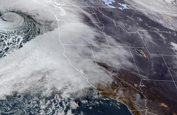
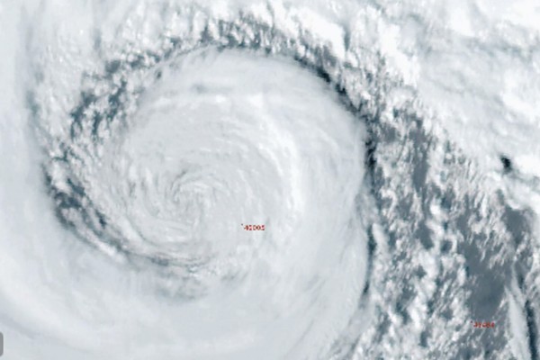
SEATTLE (AP) — What was expected to be one of the strongest storms in the northwest U.S. in decades arrived Tuesday evening, knocking out power and downing trees across the region.
The Weather Prediction Center issued excessive rainfall risks beginning Tuesday and lasting through Friday as the strongest atmospheric river — a large plume of moisture — that California and the Pacific Northwest has seen this season bears down on the region. The storm system is considered a “ bomb cyclone,” which occurs when a cyclone intensifies rapidly.
The areas that could see particularly severe rainfall will likely reach from the south of Portland, Oregon, to the north of the San Francisco area, said Richard Bann, a meteorologist with the National Weather Service Weather Prediction Center.
“Be aware of the risk of flash flooding at lower elevations and winter storms at higher elevations. This is going to be an impactful event,” he said.
Hurricane-force winds, which are gusts above 75 mph (121 kph), could be felt along the Oregon coast, according to the National Weather Service in Medford, Oregon. And near Seattle, conditions for a “mountain wave” were shaping up, bringing large, low elevation wind gusts that could cause widespread power outages and downed trees, said Larry O’Neill, director of the Oregon Climate Service and Oregon State University associate professor.
“This will be pretty strong in terms of the last 10 or 20 years,” he said. "We’ve only seen a couple storms that have really been this strong.”
More than 106,000 customers had lost power in Washington as of Tuesday evening, according to poweroutage.us. More than 11,000 had lost power in Oregon and nearly 12,000 in California.
The National Weather Service in Seattle said a peak wind speed of 68 mph (109 kph) was recorded at Crystal Mountain near Mount Rainier. A wind speed of 53 mph (82 kph) was also recorded at Ediz Hook, a 3-mile-long (4.8-kilometer) sand spit northwest of Seattle that extends from the northern shore of the Olympic Peninsula at Port Angeles into the Strait of Juan de Fuca. Winds were expected to increase in western Washington throughout the evening, the weather service said.
In northern California, flood and high wind watches were in effect, with up to 8 inches (20 centimeters) of rain predicted for parts of the San Francisco Bay Area, North Coast and Sacramento Valley.
A winter storm watch was issued for the northern Sierra Nevada above 3,500 feet (1,066 meters), where 15 inches (28 centimeters) of snow was possible over two days. Wind gusts could top 75 mph (120 kph) in mountain areas, forecasters said.
“Numerous flash floods, hazardous travel, power outages and tree damage can be expected as the storm reaches max intensity” on Wednesday, the Weather Prediction Center warned.
In Northern California’s Yolo County, crews spent Monday clearing culverts, sewers and drainage ditches to avoid clogs that could lead to street flooding. Mesena Pimentel said she hoped the efforts would prevent a repeat of floods last February that inundated her property near Woodland.
“We had about ten inches of water in our garage, had a couple gophers swimming around,” Pimentel told KCRA-TV. Woodland city officials set up two locations where residents could pick up free sandbags. Authorities urged people to stock up on food and charge phones and electronics in case power goes out and roads become unpassable.
In southwestern Oregon near the coast, 4 to 7 inches (10 to 18 centimeters) of rain was predicted — with as much as 10 inches (25 centimeters) possible in some areas — through late Thursday night and early Friday morning, Bann said. The National Weather Service issued a flood watch for parts of southwestern Oregon through Friday evening.
Washington could also see strong rainfall, but likely not as bad as Oregon and California. From Monday evening through Tuesday, some of its coastal ranges could get as much as 1.5 inches (3.8 centimeters) of rain, Bann said.
The weather service warned of high winds from Tuesday afternoon until early Wednesday for coastal parts of Pacific County, in southwest Washington. With gusts potentially topping 35 mph (46 kph), trees and power lines are at risk of being knocked down, the Pacific County Emergency Management Agency warned.
A blizzard warning was issued for the majority of the Cascades in Washington, including Mount Rainier National Park, starting Tuesday afternoon, with up to a foot of snow and wind gusts up to 60 mph (97 kph), according to the weather service in Seattle. Travel across passes could be difficult if not impossible.
Tuesday evening, fallen trees blocked the a lane on Interstate 90 in Issaquah, Washington, while rough winds and seas halted a ferry route in northwestern Washington between Port Townsend and Coupeville.
Officials also urged motorists to consider delaying travel around the state until Wednesday because of high winds and heavy snow expected in the mountains.
“It will only be a winter wonderland in the sense that you’ll be wondering where the heck you are on any given patch of land,” the Washington State Department of Transportation said on social media.
___
Weber reported from Los Angeles. Associated Press writer Lisa Baumann in Seattle contributed.


