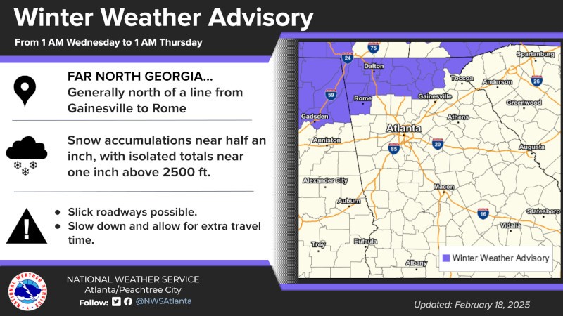
The concerns over wet, windy and colder temperatures beginning early Wednesday morning for much of northern Georgia has prompted the National Weather Service (NWS) to issue a Winter Weather Advisory to areas just north and west of Hall County.
The NWS's Peachtree City location has issed the advisory for Dawson, Fannin, Gilmer, Lumpkin, Pickens, Rabun, Towns, Union and White Counties between 1:00 a.m. on Wednesday, February 19th through 1:00 a.m. on Thursday, February 20th. That's not to say that the forecast for areas such as Forsyth, Hall, Habersham, and Stephens counties will not see some concerning weather conditions during that time.
The items from the NWS's Winter Weather Advisory includes the following for Wednesday:
- We are not expecting this to be a major/high-impact winter weather event but could certainly see localized travel issues in the higher elevations of north GA.
- There is a very small chance (< 10%) that some snow could mix in with rain as far south as north metro Atlanta, but at this time, even if we see the snow that far south, temperatures are expected to remain just above freezing which will keep the snow from really sticking on the pavement. NOTE: colder temperatures are expected the farther north you go toward the Tennessee/North Carolina state lines.
- Light snow is expected in area covered by the Winter Weather Advisory.
- Snow totals around 0.5" are expected, with the potential for amounts near 1" at higher elevations.
- Light flurries may linger across far north Georgia tonight, no additional accumulations are anticipated.
- Colder air will drop low temperatures into the teens and lower 20s across north Georgia Thursday morning, then all of north and central Georgia will see these temperatures Friday morning.
- Wind chills in the single digits to lower teens are expected across north Georgia Thursday and Friday mornings.
- The bulk of any snow accumulations should occur before 11 AM this morning in far north Georgia.
- The cold weather will affect the entire region between Thursday and Friday morning.
The potential impact from the winter weather advisory could include:
- Snow accumulations are most likely on grassy and elevated surfaces, although some less-traveled and higher elevation roadways may be impacted.
- Patchy black ice will be possible tonight into Thursday morning.
- Plants that have emerged early due unseasonable warmth earlier in the month could be damaged by the return of cold temperatures.
- Some instances of pipes freezing could occur.
AccessWDUN will continue to follow any reports of inclement weather or concerns with traffic and school/business/municipal government operation announcements during the coming hours. A link to the NWS Winter Weather Advisory can be found, here.